by Vincent Combes, Chief Geologist at Founders Metals Inc.
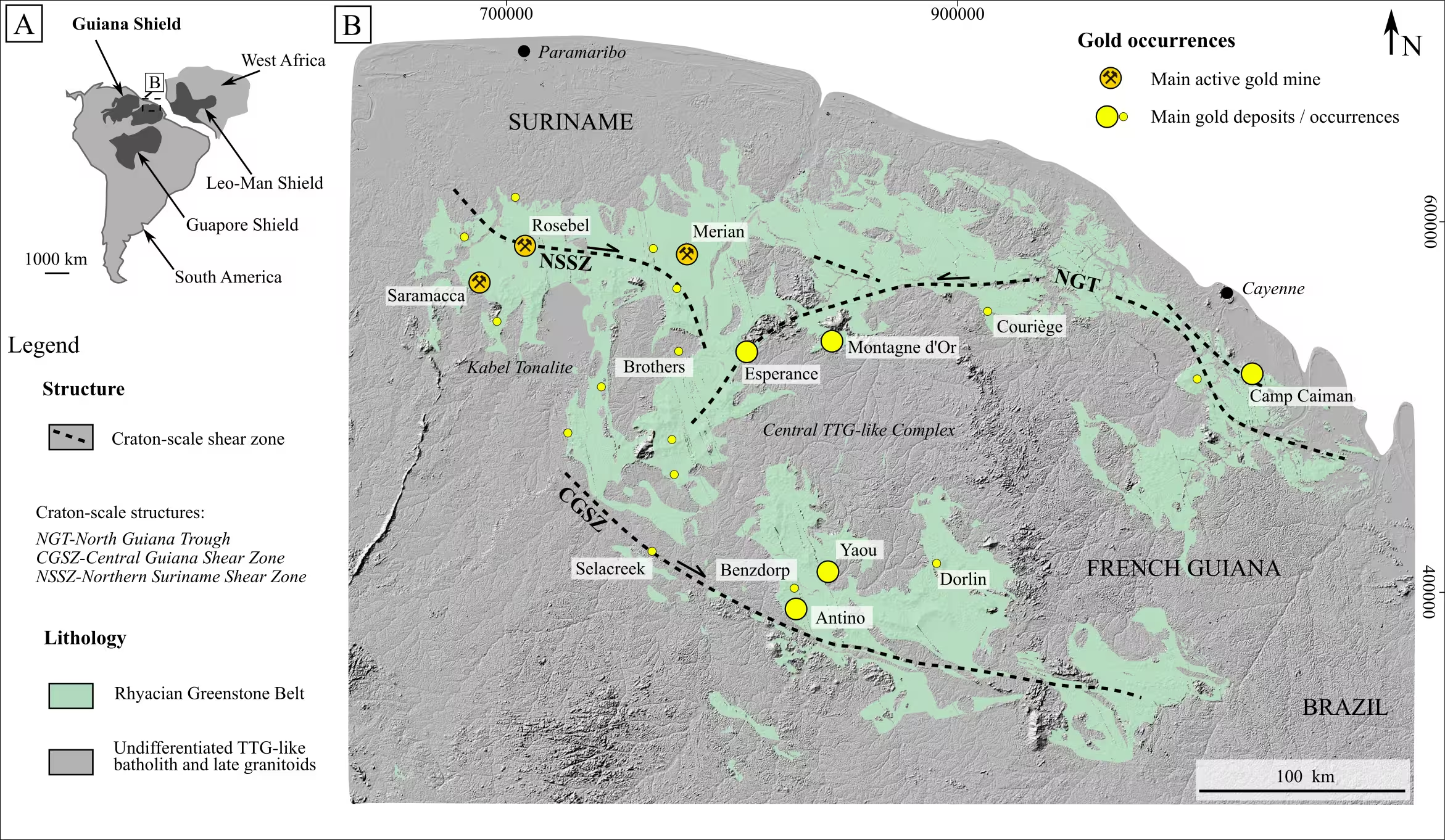
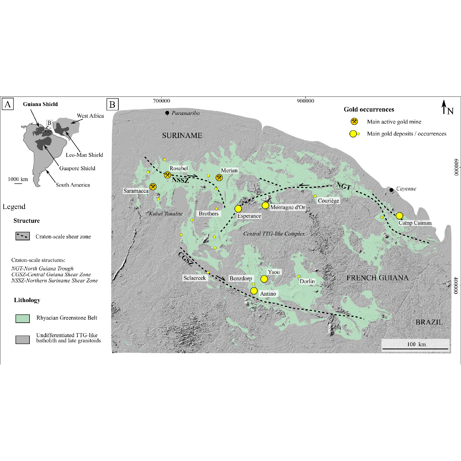
B. Overview of the main gold occurrences in the NE part of the Guiana Shield, modified from Combes et al. (2024), Kroonenberg et al. (2016), and Delor et al. (2003), highlighting the spatial distribution of the Rhyacian Marowijne Greenstone Belt over Suriname and French Guiana. Major craton scale shear zones are named after Ledru et al. (1991) and Voicu et al. (2001).
The Guiana Shield lies in the northeastern part of South America, spanning roughly 900 000 km² (347 492 mi²) across parts of Venezuela, Guyana, Suriname, French Guiana, and Brazil. It forms the northern segment of the Amazonian Craton, separated from its southern counterpart, the Guaporé Shield, by the Phanerozoic sedimentary cover of the Amazon Basin. Compared to other cratons, the Rhyacian rocks of the Guiana Shield remain relatively understudied and underexplored for gold. However, the northeastern part of the craton (Figure 1) hosts several world-class orogenic gold deposits.

B. Saprolite mapping with a trowel, the best tool for geologists who enjoy playing with mud,
C. Crossing a dried riverbed within the Central Guiana Shear Zone (CGSZ), an 8 km-wide (4.97 mi) shear zone (see Figure 1),
D. Mapping along the Lawa River (border between Suriname and French Guiana) during the ‘extremely dry’ dry season of 2024, with students from the University of Paramaribo.
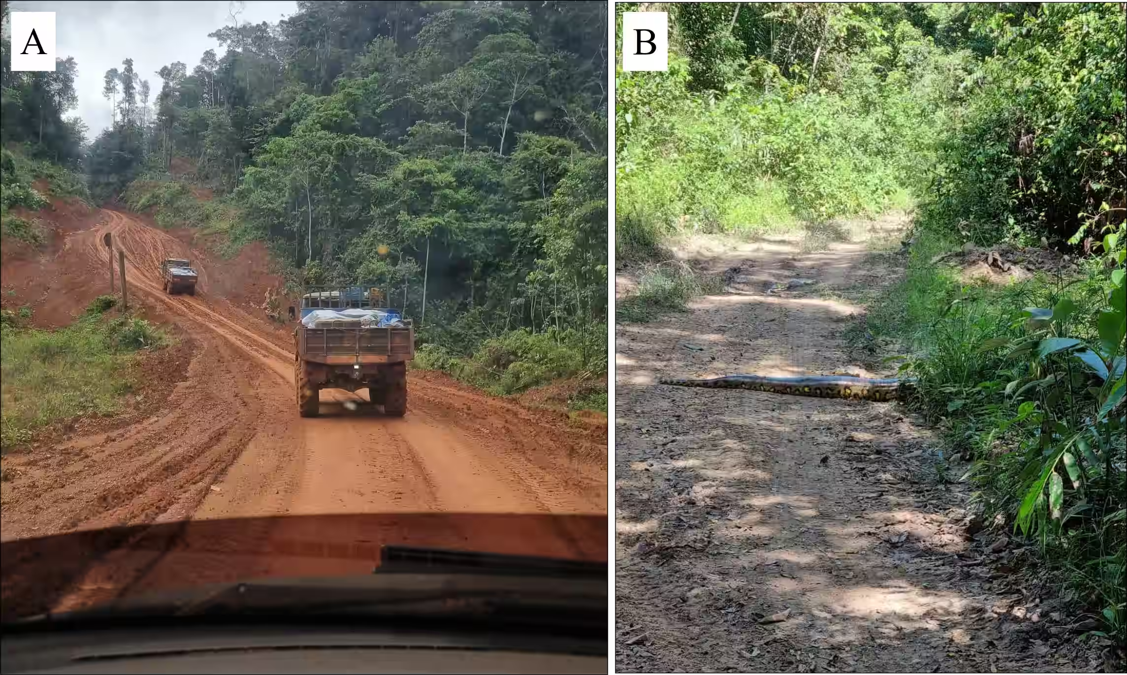
B. Typical access road to drill site in dry season with a small anaconda crossing the track (Suku Passi gold project, 2022, Suriname).
Assessing the deep weathering profile

- the preservation of primary gold as free gold in both transported and autochthonous horizons and as electrum inclusions in detrital pyrite,
- the formation of secondary gold through dissolution/precipitation processes, expressed as gold spherulites on the free gold grain surface, an Ag-depleted rim around transported free gold grains, and Ag-depleted gold micro-inclusions hosted by oxidized autochthonous pyrite.
- deep weathering and peneplanation,
- dismantlement and transport of lateritic material,
- the development of a latosol cover.
This study highlights that gold exploration in tropical environments must consider the residual versus transported nature of the horizon and the inheritance of targeted pedogenic horizons.
Finding fresh rock exposures in the jungle
In the jungle, finding fresh rock exposure is more difficult than finding gold. When a project is crossed by water, the most effective approach is river mapping by small canoe during the dry season, often with the help of local Amerindians. Exceptionally low water levels over the past two years revealed rare exposures of fresh rock (Figure 2C and D).
In most cases, the soula (English equivalent: rock bar with rapids) is the primary area of exposure. However, these outcrops typically represent the least deformed geological domains, while the more highly strained rocks remain submerged beneath water. Small creeks are another useful way to find grab samples and measure structures, though they are not always the best exposures. Finally, small-scale mining activity also creates exposures. Saprolite mapping has the added advantage that saprolite pieces are easy to remove, leaving a clean plane where lineations can be observed and measured.
Building a multi-scale structural framework
In the Guiana Shield, drilling is possible all year round. By contrast, in Canada and other northern jurisdictions, the field season is limited to a maximum of four months, which balances out the effect of the wet season. In the end, logging the drill cores with attention to the timing of deformation remains essential to supporting a multi-scale structural analysis and understanding a deposit.
Our paper ‘District to mineral-scale geometry of the world-class Antino orogenic gold system, southeastern Suriname, Guiana Shield’, published in March 2025 in Ore Geology Reviews, emphasizes the value of integrating multi-scale data for gold targeting, particularly through detailed vein analysis. It also shows the importance of academic work, on this occasion carried out with the GeoRessources laboratory in Nancy, France, in complementing exploration.
All lab work conducted at the GeoRessources laboratory in Nancy, France.
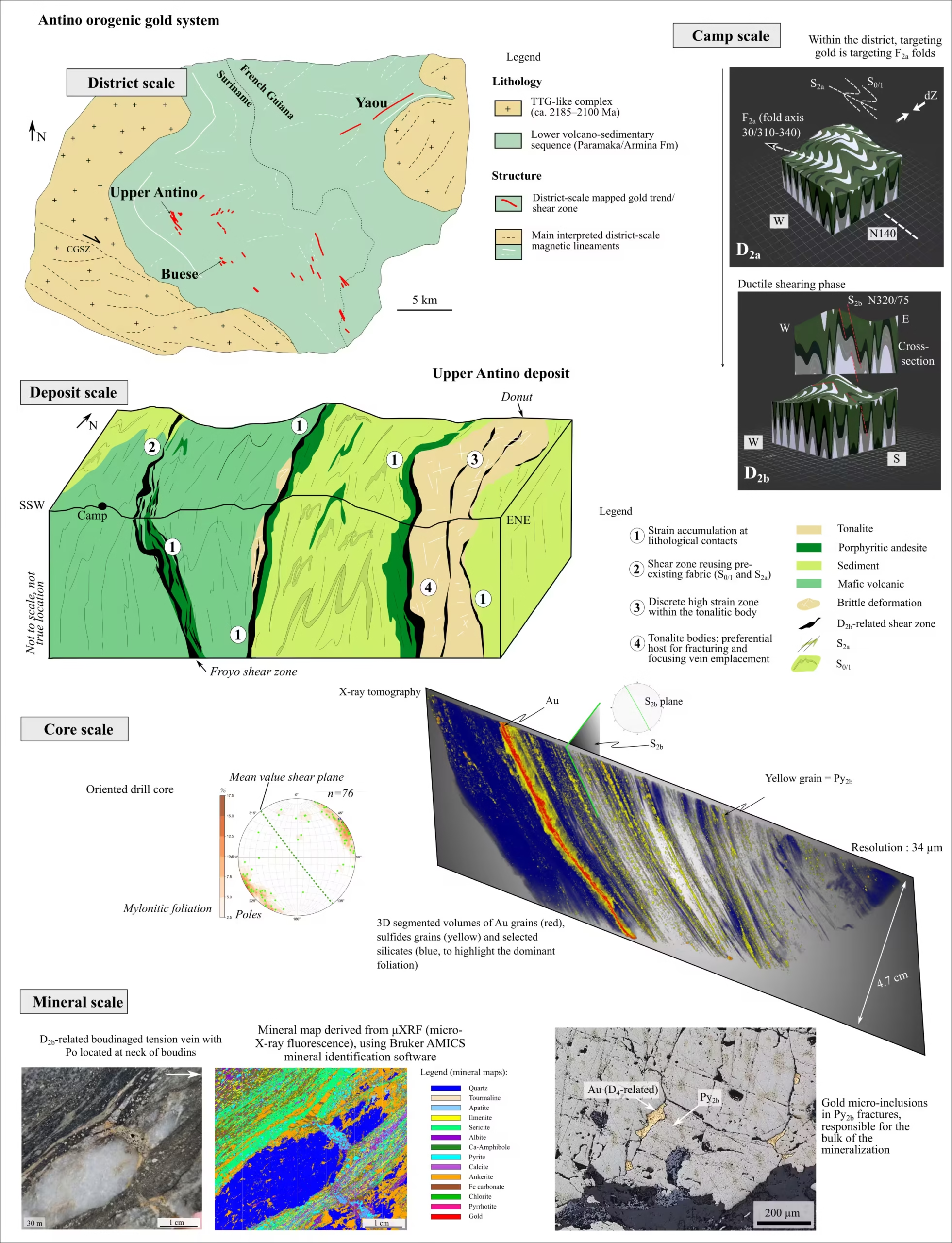
The Antino orogenic gold system (Figure 1 and 5), chosen in this paper as a case study, is actively explored by Founders Metals Inc., a Canadian gold exploration company backed by a strategic partnership with Gold Fields Limited.
The Antino–Yaou–Benzdorp gold district (Eastern Suriname) hosts multiple gold deposits preferentially developed within intermediate intrusive bodies (intrusion-hosted orogenic gold) and at lithological boundaries (shear zone-hosted orogenic gold). Within the district, the spatial distribution and orientation of gold camps, such as the Antino gold camp, are controlled by the location and shape of TTG complexes. These rigid bodies act as buttresses for strain accumulation within the volcano-sedimentary sequence. At the deposit scale, zones of enhanced deformation are located at lithological contacts, along antiformal limbs, and along the edges of tonalitic intrusive bodies. These intrusions were preferential hosts for later brittle deformation and related brecciation and veining.
The first compressional stage, D1, produced the ENE fabric, while the second stage, D2a, was responsible for the main folding event during ongoing compression under NE-SW-oriented shortening and for the formation of the axial planar fabric S2a. NW-oriented dip-slip reverse shear zones are related to the D2b deformation stage and host both metric fault-fill veins and progressively deformed tension vein arrays (tva2b). Locally, a refolding of the S2b mylonitic foliation is observed (D3 deformation stage). This progressive ductile deformation is then locally overprinted by a polyphase brittle deformation stage (D4), expressed by breccias, extensional veins, and fractures. Strain axis orientations for shearing (NE-SW shortening) and for refolding of the mylonitic segments (NW-SE shortening) control the location of low-stress sites and, therefore, the location and orientation of gold mineralized shoots.
At the mineral scale, micro X-ray fluorescence scanning on core samples reveals that early D2b veins act as more competent sites for later gold deposition related to D3 and D4. Boudin necks (of tva2b) and hinges of folded mylonite are serving as low-stress sites for pyrrhotite and gold precipitation. The D4-related brittle overprinting plays an important role in the total gold budget, through remobilization and/or the input of new gold, and is responsible for the highest gold grades encountered in the project. Both shear-zone-hosted and tonalite-intrusion-hosted systems demonstrate the importance of rheology in building an orogenic gold system.
Conclusion
Combining such multi-scale structural (academic) research with an exploration campaign is invaluable for better targeting of mineralization and understanding mineralized shoot geometry, an approach that is often lacking in the junior exploration industry. Although the Guiana Shield remains relatively underexplored, it currently represents the Precambrian craton with the greatest potential for Tier One gold discoveries, offering significant opportunities for future exploration.
References
Bardoux, M. (2022). OCSH, IH and IR rhyacian gold deposits of the Guiana shield. In SAXI- XII Interguiana Geological Conference 2022, Georgetown, Guyana.
Combes, V., Eglinger, A., Andre-Mayer, A.-S., Teitler, Y., Heuret, A., Gibert, P., Beziat, D. (2021a). Polyphase gold mineralization at the Yaou deposit, French Guiana. Geological Society, London.
Combes V., Teitler Y., Eglinger A., Andre-Mayer A.-S., Heuret A., Pochon A., Cathelineau M., Gibert P. (2021b). Diversity of supergene gold expressions and implications for gold targetting in an equatorial regolith (AMG’s Couriege Exploration Prospect, French Guiana). Geological Society, London, Special Publications, 516.
Combes, V., Eglinger, A., Andre-Mayer, A.S., Teitler, Y., Jessell, M., Zeh, A., Reisberg, L., Heuret, A., Gibert, P. (2022). Integrated geological-geophysical investigation of goldhosting Rhyacian intrusions (Yaou, French Guiana), from deposit- to district-scale. Journal of South American Earth Sciences, 114, 103708.
Combes, V., Eglinger, A., Bhoelan, R., LaPoint, D. (2024). Batholith-hosted polyphase gold mineralization at the Brothers project, eastern Suriname. Journal of South American Earth Sciences, 133, 104740.
Combes, V., Eglinger, A., Voegeli, P., Bhoelan, R., Bertoni, C., Padget, C., Andre-Mayer, A.-S. (2025). District to mineral-scale geometry of the world-class Antino orogenic gold system, southeastern Suriname, Guiana Shield. Ore Geology Reviews, 180, 106575.
Delor, C., Lahondere, D., Egal, E., Lafon, J.-M., Cocherie, A., Guerrot, C., Rossi, P., Truffert, C., Theveniaut, H., Phillips, D., Avelar, V.G.d. (2003). Transamazonian crustal growth and reworking as revealed by the 1:500000 scale geological map of French Guiana. Géologie de la France, 5–57.
Hainque, P.J., Lacroix, B., Trap, P., Bertoni, C., Eckfeldt, M., Lahondes, D., Toorn, J., Goff, E. (2024). Polyphase deformation and structural controls on Rhyacian gold mineralization at the Oko West deposit, Guyana. Journal of South American Earth Sciences, 153, 105327.
Kroonenberg, S.B., de Roever, E.W.F., Fraga, L., Reis, N., Faraco, T., Lafon, J.-M., Cordani, U., Wong, T. (2016). Paleoproterozoic evolution of the Guiana Shield in Suriname: a revised model. Netherlands Journal of Geosciences, 95, 491–522.
Ledru, P., Laserre, J.L., Manier, E., Mercier, D. (1991). Le Proterozoique inferieur nord guyanais: revision de la lithologie, tectonique transcurrente et dynamique des bassins sedimentaires. Bulletin de la Société Géologique de France, 162 (4), 627–636.
Tedeschi, M., Hagemann, S.G., Davis, J. (2018). The Karouni Gold Deposit, Guyana, South America: Part I. Stratigraphic Setting and Structural Controls on Mineralization. Economic Geology, 113, 1679–1704.
Voicu, G., Bardoux, M., Stevenson, R. (2001). Lithostratigraphy, geochronology and gold metallogeny in the northern Guiana Shield, South America: a review. Ore Geology Reviews, 18, 211–236.
For more information: Get in touch with Vincent on LinkedIn